
The 10th Edition Grandfather Ranger District Map Is Here
The Grandfather Ranger District may occasionally get called the “other Pisgah,” but anyone who has explored it knows there is nothing secondary about it. From the rugged terrain of Linville Gorge and Wilson Creek to the trails around Old Fort, Lake James, Grandfather Mountain, and Mount Mitchell, this corner of Pisgah National Forest contains a lifetime’s worth of adventure.
We released the 10th Edition of our Grandfather Ranger District map in early April 2026. As always, the goal was not simply to reprint the map, but to make it more accurate, useful, and current for hikers, mountain bikers, trail runners, anglers, paddlers, equestrians, and anyone else heading into the woods.
For this edition, we worked closely with staff from the U.S. Forest Service Grandfather Ranger District and received valuable input from other local stakeholders who know these trails and public lands well.
Showing Hurricane Helene’s Impact
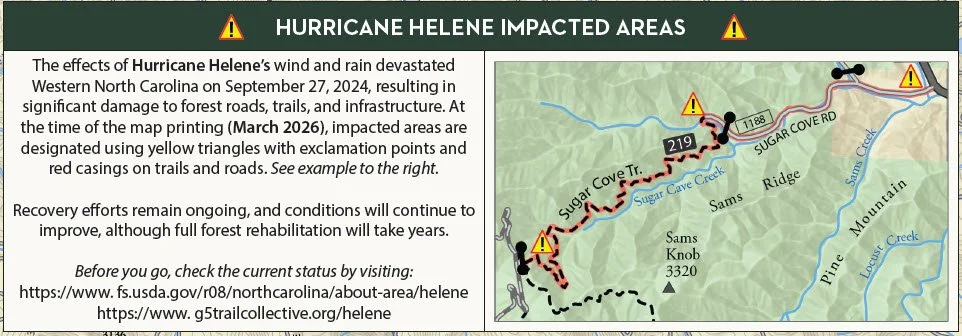
Hurricane Helene Information from the Grandfather Ranger District map
The most important addition is the designation of areas affected by Hurricane Helene.
Helene’s wind and rain caused extensive damage to forest roads, trails, bridges, and other infrastructure throughout Western North Carolina. On the new map, impacted areas are identified with yellow warning symbols and red casings along affected roads and trails.
These designations reflect conditions at the time the map was printed in March 2026. Recovery work continues, and conditions will change as trails reopen and repairs are completed. Before heading out, always check the current status of roads, trails, and recreation areas through the U.S. Forest Service’s Helene recovery information or the G5 Trail Collective Hurricane Helene page which includes an interactive map.
New and Updated Trails
The 10th Edition also includes several important trail additions and revisions:
Deep Cove Trail, extending from the Gateway Trail System
Jerdon Mountain Connector
Camp Rock Trail
Catawba View Trail in the Gateway Trail System
A new trail segment along Allison’s Ridge for the Catawba Falls Loop
We also zoomed the Gateway Trails inset map out slightly to show a larger area, including Catawba View Trail and the southern portion of Deep Cove Trail. Additional refinements were made to feature labels, map text, and other small details throughout the map.
A Lot of Ground in One Map
The Grandfather Ranger District map covers an enormous and varied part of Western North Carolina, including:
Linville Gorge Wilderness, Wilson Creek, the Wilson Creek National Wild and Scenic River, the Gateway Trail System, Heartbreak Ridge, Kitsuma, Catawba Falls, Lake James, Mount Mitchell State Park, Grandfather Mountain State Park, the Blue Ridge Parkway, and much more.
Whether you are planning a quick ride near Old Fort, a day beside Wilson Creek, or a backcountry trip into Linville Gorge, the updated map is built to help you understand the terrain and find your way.
The 10th Edition Grandfather Ranger District map is available now in our online shop and from many of our retail partners throughout Western North Carolina.
Find the Map Near You
The 10th Edition Grandfather Ranger District map is available in our online shop and at most local outfitters and outdoor retailers throughout Western North Carolina. Visit our Where to Buy page to find a retailer near you.
And if your favorite local outfitter does not have the new edition yet, ask them to stock up. Supporting local retailers helps keep good maps—and good trail information—available in the communities closest to the places we all love to explore.
Find your way. Lose yourself.